

Magical Mhe Mhe Pokhari cultural trail in Lamjung
Nepal’s tourism sector has long relied on only a handful of popular trekking destinations. However, the need of the hour is to identify and explore new places with tourism potential. If we make the effort, we can find countless unexplored destinations across the country that can offer travelers even more diverse experiences. Recently, we explored one such place, a destination that very few people have heard about.
In the northeastern part of Lamjung district, in Gandaki Province, lies a magnificent destination offering breathtaking views of more than a dozen mountains, including Mt Machhapuchhre, Mt Dhaulagiri, Mt Ngadi Peak, and Mt Boudha. This place is home to more than seven lakes, each with its own name and unique stories, making it distinct from other popular tourist spots. This is the Mhe Mhe Pokhari Cultural Trail Trek.
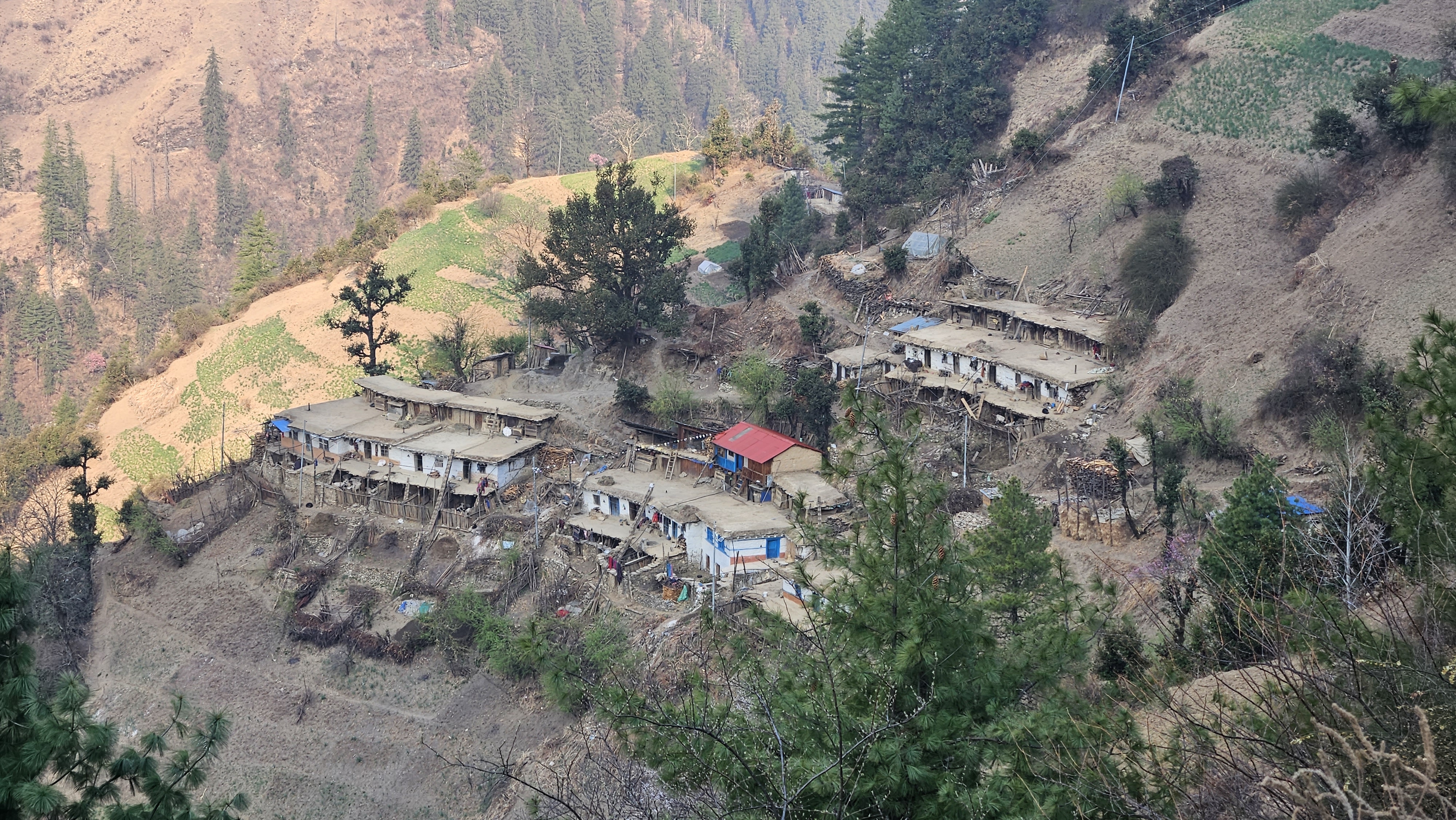
We—a team of 32 trekkers from “Happy Hikers” and “The Walkers,” along with 35 porters, kitchen staff, and guides—officially inaugurated the historic Mhe Mhe Pokhari trail in Dordi Rural Municipality-7 of Lamjung district. Upon reaching Hilebesi, approximately 180 km from Kathmandu, around 100 villagers welcomed us with garlands and tika.

After the warm and grand welcome at Hilebesi, we traveled by bus to Upper Khinchowk, about an hour’s drive away. There, another group had been eagerly waiting for nearly three hours to greet us with lively cultural dances and music performances. Although we wished to stay longer and enjoy the program, fatigue caught up with us. After a hearty dinner, we retired to our homestays.
The next morning, after enjoying sel roti along with curry and tea for breakfast, we gathered at a designated spot to begin the trek. The air was filled with warmth and smiles as the mothers’ group bid us farewell, applying tika and showering us with blessings.

Soon after leaving the village and entering the jungle, the steep ascent, and the terror of leeches, began. However, the higher we climbed, the better the views became. On the first day, we trekked for about six hours, ascending from 1,200 m to 2,570 m. We set up our tents at Pauli Danda, where we also found a small shed. It was here that we caught our first glimpse of the majestic Mt Boudha and Mt Himalchuli.
By the time we reached our first stop, the sun was setting toward the horizon, casting a golden glow across the mountains. The moment was unforgettable, although clouds had already covered some of the surrounding ranges.

The next morning, we witnessed a captivating sunrise from Pauli Danda. The eastern sky glowed in deep shades of red and orange, and from the ridge we could see more than eighteen majestic peaks, Mt Manaslu and Mt Himalchuli to the north, and Mt Machhapuchhre and the Annapurna range to the west. After breakfast, we set off for our next destination, picking jungle fruits like chutro (berberis) and raspberries along the way.
The trail was so tranquil and enthralling that we were completely absorbed in its beauty, hardly noticing when we reached Khole Pokhari, an open ground rather than a pond. According to our guide, there used to be a beautiful pond here. However, it was believed that whenever two people went near it, only one would return. In other words, the pond was thought to claim a life. In anger and fear, villagers eventually cut down part of the hill and drained the pond.

Later, it was believed that the spirit had settled at Barah Pokhari, just below the hill, prompting villagers to build a temple there. Listening to these stories, we reached Thodi Danda, our third-day station. We set up our tents while watching an astonishing sunset. As night deepened, the temperature dropped, and because our tents were pitched on a slope, we struggled to sleep comfortably.
On the fourth day, barely ten minutes after starting our walk from Thodi Danda following breakfast, we reached a stunning spot surrounded by rhododendron trees and a wide green meadow. From there, the Manaslu Himalayan range stood directly before us, with Mt Annapurna visible to our left.

We spent some time taking photos and videos. As it was our acclimatization day, we walked only a short distance and spent the night at Komro Danda. Situated at an altitude of 4,000 m, Komro Danda was truly a wonderful place. The view of the mountains and the sunset from there remains vivid in my memory.
Despite its beauty and tranquility, the area suffers from a lack of water. Heartfelt thanks go to the porters, who walked nearly an hour to fetch water and cook for us. Recently, the local authority constructed a dharmashala there, providing a proper resting place for travelers. Once the water problem is resolved, the journey will become much easier. We spent the night at the dharmashala.

The next day, having been informed that the trail ahead would be long and challenging, we began walking soon after breakfast without delay. We had now entered the alpine zone. The trail grew narrow and demanding, but the stunning views of Boudha Himal made the journey feel vibrant and rewarding.
As there was no open ground to pitch tents, we had to walk directly from Komro Danda to Mhe Mhe Pokhari Base Camp to spend the night. We had noodles for lunch that day. The trail after lunch proved to be the most challenging and adventurous part of our journey. The weather was cold, and thick fog blanketed the surroundings. The path was rocky, narrow, and difficult, forcing us to walk while taking support from the rocky walls.

Each time we reached the top of a hill, another appeared right in front of us. After much hardship, we finally crossed two hills—Tare Deurali (4,350 m) and Chabi Danda (4,380 m)—and reached Mhe Mhe Pokhari Base Camp.
A dharmashala had been built there, so half of our group took shelter inside while the rest stayed in tents. On the sixth day, after walking for about twenty minutes, we were rewarded with the serene Mhe Mhe Pokhari Lake. According to a local guide, the lake got its name when a person, seeing its vastness for the first time, was so shocked and dizzy that the words “Mhe Mhe” escaped his mouth. In the Gurung language, Mhe Mhe is an expression used when one feels dizzy.

It is believed that those who make a wish upon reaching the lake will have it fulfilled. A few minutes of uphill walking led us to several other stunning lakes, including Narsingh Lake, Talwar Lake, Dhalkyu Lake, and the mother of all lakes: Dudh Pokhari. Each lake appeared in a different color, some green and others blue.
Some members of our group even scaled Mhe Mhe Peak (5,049 m), also known as Mhe Mahe Pass, with the help of a guide. Those who did not attempt the peak spent their time around the lakes, quietly soaking in the beauty and capturing photos and videos.
On the seventh day, after packing our lunch, we descended straight to Thodi Danda and spent the night there. The eighth day involved a long descent to Duwar via Barah Pokhari. As we reached the village, we found the villagers eagerly waiting to welcome us.

Witnessing the welcome ceremony reminded us that the cultural saying “Atithi Devo Bhava” (Guests is god) still thrives in Nepal. At the end of the trek, we realized that Nepal continues to hold countless hidden gems, waiting to be explored and shared with the world.


Into the trail of North Annapurna Base Camp
Nepal is blessed with endless natural beauty, from its jaw-dropping scenery to its awe-inspiring mountains and tranquil and shimmering lakes, making it truly special. Whenever I wish to add new memories by exploring the limitless possibilities of life, I venture into new corners of nature with backpacks eager to see the unseen views and uncover the untold stories, beautifying life and renewing my inner selves.
This time I along with other enthusiastic trekkers and a guide from the WalkNepalWalk team, a hiking and trekking group, travelled to a beautiful and soul-soothing place, which has gained immense popularity in recent times, where nature connects the soul to serenity. This is the journey to North Annapurna Base Camp situated at an altitude of 4,190 meters from sea level.
As per the itinerary, a team of 18 people, gathered at Gongabu Bus Park at 5 in the evening. Though we boarded a bus at 6 pm, we crossed Kalanki, which is around 20 minutes from Gongabu, at 8 pm because of a heavy traffic jam. After passing Thankot, we took our first break of the journey at Naubise, where we paused for a while to have some light snacks. As we were travelling at night, the lights of the moon and stars were making the journey absolutely magical. But the sad part is that the highway has not been upgraded yet.

With fun and laughter, we did not even realize that we had reached Abu khaireni, stop for dinner that night. The dinner made us all sleepy and everyone drifted off to sleep. It was around 8 am, when we reached Tatopani, where the jeeps booked in advance were already waiting for us. We had breakfast and left for Humkhola. The jeep journey was thrilling, bumpy and unforgettable as well. Thanks to WalkNepalWalk, everything from transportation to our hotel arrangements was completely hassle-free. This felt even more reassuring when we saw the recent chaos in North ABC due to overcrowding, with many exhausted trekkers forced to spend nights outside in the freezing cold.
Situated at an elevation of 2,840 meters, Humkhola is popular for hydropower projects. There are around five hydel projects currently in operation in Humkhola and two are under construction. It is a good example that if we use natural resources in a good way, it can be useful for many other purposes.
After two hours of off-road travel, we reached Humkhola. Without wasting time, we started the hike at around 11:30 am as we were already two to three hours late then as planned. The more we moved ahead, the more it felt that we were going back to the old days, when we used to walk freely without any worries. Life was simple and full of warmth.

After treading for around two hours along the trail carved by the Nilgiri River, which originated from melting glaciers of Nilgiri Himal, we reached Phutphute Waterfall, one of the highlights of this trek. Walking by the river, hearing the sound of water flowing and birds chirping encouraged us to move forward. The official name of this trail is the Maurice Herzog Trail, named after the French mountaineer, late Maurice Herzog, along with his teammate Louis Lachenal, made first ascent to Mount Annapurna I which stands at an altitude of 8,091 meters.
The trail, however, recently became popular among the travelers as the North Annapurna Base Camp Trek. We spent some time enjoying the waterfall taking photos and videos to recount the memory. In addition to the beautiful surroundings, we also had some mouthwatering dishes there. After walking uphill for around half-an-hour, we reached Sandikharka. The view ahead was astonishing. The forest was alive with vibrant colors and fresh earthy smell of damp soil and fallen leaves made the environment more attractive.
We then walked past Gufaphant (3,319 meters) and reached Busket Mela (3,530 meters), the first station of our jaunt. We stayed in the tents which were surprisingly cozy and warm. We crossed numerous bridges in this trek which were connecting people with nature.

On the next day, we woke up at around 4 am and headed towards Panchakunda Lake guided by headlights. We could see the clear sky with no trace of clouds and the majestic snow-capped mountains standing tall and smiling in front of us, as if she knew the answer to all the questions. She knows what people want and time of blooming and fading. We felt that we were travelling beyond the world with the inner self.
The trail to the base camp is gradually being developed. The problem arises when people go to the untamed pristine areas and leave litter everywhere. Travelling is not only about enjoying the views and taking photos, we should also take the responsibility to protect the environment. After a 45-minute walk, we reached Dharmashala. We could find a hut constructed by ACAP for the travelers to take rest.
The trail ahead was challenging as many sections were frozen as we were travelling in November. We had to walk very carefully. But still some of the friends fell down. Fortunately, no one sustained serious injuries. Walking continuously for around three hours led us finally to Panchakunda Lake.

The lake situated in Myagadi district was established as a tourist destination recently. The lake remained hidden among the Nepalis living in the country and abroad for years as only mountaineers used to come here for expeditions. Nestled at the foot of Mt Annapurna, it reminds us of the serene beauty of Shey Phoksundo Lake.
It has been said that the lake splits into five ponds when it freezes and reunites into one when the snow melts and that’s how the lake got its name. When we reached the lake, half of it was frozen while half remained unfrozen. The unfrozen part of the lake was turquoise in color. It felt like witnessing a piece of heaven on earth.
Since it was freezing cold. We could hardly stand outside for five minutes. Hence, we stayed at the tea house sipping hot tea until the sun rose. We left for the base camp at around 8 am. The North Annapurna Base Camp is not that far from Panchakunda Lake. We could reach the base camp in around a 30-minute walk.

The view from the base camp was priceless and unreal. We could clearly see Mt Annapurna I (8,091 meters) and Tilcho Peak (7,134 meters) standing tall in front of us while Mt Nilgiri rose just opposite to it. That is why, Panchakunda Lake holds a unique significance. After feasting our eyes on nature's splendor, we came back to Panchakunda Lake to have lunch. We then descended directly to Busket Mela and then to Gufaphant to spend that night.
The following day, we hiked towards Humkhola at around 8 am from where we took jeeps to Tatopani. Then we had delicious Thakali khana, dipped into a natural hot spring and wrapped up our journey. Though the trek ended, we came back home with countless memories which will stay with us forever.


Exploring the beauty of Dhorpatan
Dhorpatan Hunting Reserve is Nepal’s only game sanctuary. Established in 1983, it spans 1,325 sq km, touching the districts of Baglung, Rukum, and Myagdi. I had been hearing about the untamed beauty of Dhorpatan since childhood and always longed to see it. But as I grew older, adult responsibilities, jobs, and family commitments pushed that wish aside for years.
I believe that anyone who has heard of Dhorpatan feels its pull, the desire to experience its raw, untouched beauty. So, I finally ventured into this hidden paradise of Nepal that many have heard of but few have truly explored. I was joined by a group of acquaintances, for adventures are best when shared.
We gathered at the New Bus Park in Gongabu at 3:30 pm to begin our 400 km overnight journey from Kathmandu. My long-cherished dream to see Dhorpatan—a land of vast grasslands, dense forests, rivers, and timeless mountains—was finally taking shape. As we left behind the bustle of Kathmandu, the cityscape gradually gave way to lush hills and serene valleys.

The bus stopped at Naubise for tea and later at Damauli for dinner. The Prithvi Highway up to Muglin was in miserable condition, but beyond that, the road improved, carrying us smoothly toward Pokhara. Fatigue soon took over, and I fell asleep scrolling through Facebook.
When I opened my eyes, it was around 7 am, and we had already reached Burtibang, the second-largest commercial center in Baglung district. Since we hadn’t eaten dinner the night before, we decided to have breakfast before continuing our journey to Dhorpatan.

At around 9 am, the jeep we had booked from Kathmandu arrived. The driver told us it would take roughly three hours to reach Dhorpatan from Burtibang. We drove along the river, passing cascading waterfalls and small hamlets. The road, however, was rough and poorly maintained. With rain adding to the challenge, the drive became an exhilarating adventure.
When we finally entered Dhorpatan, a thick fog blanketed the valley, concealing everything in sight. But as the mist began to lift, the view before us was simply breathtaking. Wide grasslands dotted with wildflowers, canals glinting in the sunlight, crystal-clear rivers winding through meadows, herds of grazing horses, and lush forests. It felt like another world.

‘Dhor’ means marshland, and ‘Patan’ means flat meadow. These meadows are home to blue sheep, Himalayan tahr, and other wildlife. After checking into our hotel and having lunch, we rested for a while and spoke with the owner about places to explore in the valley.
Following his suggestion, we set out for a place called Kang to see a wooden bridge that had recently become quite popular. A 45-minute jeep ride followed by a 20-minute walk brought us to an enchanting spot. There were rolling hillocks blanketed with wildflowers of every imaginable color, the turquoise Uttarganga River flowed gently below, and we could see a backdrop of verdant hills. The sheer beauty left us speechless. We spent hours taking photos and videos, hoping to capture even a fraction of what we felt.

After feasting our eyes on nature’s splendor, we went in search of more vibrant wildflowers and later set up a tent by the river to enjoy the scene until dusk. We returned to the hotel afterward, had dinner, and went to bed early.
The next morning, we woke up late, as the hotel owner had told us that our next stop, Bukipatan, could be reached in five to six hours of trek. After breakfast, we began our journey at around 10 am. The trail was scenic and gentle from the start, leading us through lush forests and along a lively river. There was only one teahouse along the way, where we stopped for tea and noodles.

Suddenly, it began to rain. We put on our raincoats and continued toward Thade Khola. Since we had enough time, we paused often to enjoy the views and document the journey through photos and videos.
We reached Bukipatan around 3 pm. As it was raining heavily, we spent the evening playing games inside a large tent that sheltered about 25 people that night. Dinner was served around 11 pm, after which we went to sleep to the sound of rain drumming on the tent.

At dawn, we began our hike, guided by the soft glow of headlamps. When we reached Tikadhar, the sun was just rising, painting the sky in shades of pink, orange, and gold. The sight was surreal, dreamlike, and unforgettable.
The weather favored us that day, offering clear views of the stunning landscape. We spent a couple of hours soaking in the serenity, surrounded by wildflowers and whispering wind. As fog slowly enveloped the valley and the air turned cold, we descended back to Bukipatan for breakfast before returning to Dhorpatan. Two of our friends boarded a night bus to Kathmandu, while the remaining four of us took a jeep to Pokhara, grateful to have finally lived the dream of Dhorpatan.


Jumla to Rara: The forgotten trail
Not long ago, people had to walk for days and spend nights in assorted places to reach Rara Lake, tucked away in the mid-western region of Nepal. But with the construction of roads, the number of people treading through the path had significantly gone down and it took a toll on people who earned their livelihood from the hotels, homestays and shops they ran in the area. By degrees, people started quitting their businesses and switched to another profession.
Nestled at an altitude of 2,990 meters and spanning 10.8 square kilometers across Jumla and Mugu districts, Rara Lake is Nepal’s deepest freshwater lake.

Popular for its unruffled and splendid nature, the clean and pristine blue waters never fail to mesmerize visitors.
Turning the pages of history, Rara Lake was known as “Rara Daha” for years. Once, when late king Mahendra was traveling around the country on a helicopter, he happened to reach the basin. The enchanting beauty of the waterbody lured King Mahendra, impelling him to describe the lake as ‘Swarga ki Apsara”. He later named the lake as Rara Lake.
On April 24, 2015, my friends and I planned a trip to Rara Lake. But the very next day, Nepal was struck by a devastating 7.8 magnitude earthquake, claiming nearly 9,000 lives, injuring 22,000, and causing widespread destruction.
Along with the earthquake, our plan to visit the largest and deepest freshwater lake surrounded by magnificent conifer forests was also disrupted by the unforeseen event.
They say when you truly desire something, the universe conspires to make it happen. A decade later, some friends planned a trek to Rara via Jumla, following an old route to explore the rich cultural heritage of Nepal’s western hills. I couldn’t resist joining—this was my chance to finally witness the legendary beauty of Rara Lake which I had been hearing the bewildering tales.
Gulping down the hearty breakfast, I headed to Gongabu Bus Park where other friends were waiting for me.

Our adventure began at 7 am, growing more thrilling with every turn—until we hit a massive traffic jam in Gaindakot, Nawalparasi. Taking a detour via the Kaligandaki corridor added an extra 100 km, but it spared us a 24-hour gridlock.
The Karnali Highway, linking Surkhet and Jumla, was an adrenaline-pumping experience—narrow, rugged, and carved through rocky cliffs. Watching the Karnali River rush beneath Kakilot’s steep drops was both terrifying and exhilarating. As we entered Jumla, the roads improved, and the scenery transformed.
Driving along the Tila River at sunset, with apple orchards and golden paddy fields stretching beside us, felt like a dream. Soon, we reached Khalanga, Jumla’s district headquarters, where we were warmly welcomed by Hari Bahadur Rokaya, an international marathon runner and Guinness World Record holder. Despite his global fame, he remains underappreciated in Nepal. He even arranged two of his students as our guides.
Before starting our trek, the next morning, we explored Khalanga, offering prayers at Chandan Nath Baba and Bhairabnath Temple for a safe journey.

The trail wound past glistening streams, stone houses nestled among apple farms, and cherry blossoms in full bloom—like a scene from a postcard.
After a three-hour uphill hike, we reached Chehre for a local breakfast, then continued to Danfe Lek (3,800 meters), a challenging climb due to the steep ascent and altitude.
From Danfe Lek, the view of Khalanga Valley and Jumla was surreal—snow-dusted peaks, rhododendron and pine forests, and vast meadows stretched before us.

Reaching Khali, I was spellbound: endless grasslands, crystal-clear streams, grazing sheep, and snow-capped mountains made me feel like I’d stepped into a fairy tale. The sheer beauty brought tears to my eyes—yet it saddened me to think how such pristine landscapes are often exploited for short-term gain.
After lunch, we trekked until dusk, staying overnight in Nyaurigad, a quaint hamlet by the Tila River.
Over dinner, we learned that the late Prince Dipendra and Princess Shruti had once stayed there during a hunting trip.

The next morning, we descended through villages like Bumro and Kabra, passing lush rhododendron forests and immersing ourselves in local culture. Breakfast in Chautha and lunch in Bhubhule (the gateway to Mugu and Rara National Park) fueled us for the day’s toughest challenge: crossing Ghuchi Lek. We spent the night by the Jyari River, where the lodging was surprisingly better than the previous stop.
On the third day, we finally reached Rara Lake via Jyrai Village and Salleri. Its crystal-clear waters, vibrant fish, and emerald hills left me speechless—no childhood tales had done it justice. We soaked in the views, capturing photos and videos, while a question nagged at me: Why hasn’t Nepal promoted this paradise to the world?
A boat ride across the lake offered fleeting glimpses of snow-capped peaks through the fog. Later, we rode horses to Murma Top Eco Resort, hoping for clearer skies the next day. But luck wasn’t on our side—rain loomed overhead. “On a clear day, you can see Humla, Jumla, Bajura, Badimalika, Dolpa, even China,” our guide said wistfully.

Undeterred, we pressed on toward Sinja Valley, tackling the trek’s toughest stretch: Chuchhemara Lek (4,039 meters), the highest point in Rara National Park. The steep climb felt effortless amid the breathtaking scenery—century-old deodar trees, dark pink rhododendrons, secluded lakes, and sprawling meadows.
A local mentioned this trail was once favored by German and French trekkers but has faded into obscurity due to the Maoist insurgency and new roads bypassing it.
Reaching Chuchhemara’s jagged peaks surpassed all expectations. Exhausted, drenched, but exhilarated, we finally arrived in Sinja Valley—the birthplace of the Nepali language and the national dress, Daura Suruwal.

The final leg of our journey took us from Sinja back to Khalanga. The turquoise Hima River, apple orchards, thatched-roof homes, and rhododendron forests evoked comparisons to Kashmir—earning Jumla its nickname, “Nepal’s Kashmir.” My dream of visiting Kashmir felt fulfilled here. As dusk fell at Jaljala Pass (3,800 meters), we faced our longest, toughest day, reaching the hotel by 10 p.m.

With hearts full of memories and promises to return, we boarded the bus to Kathmandu at 5 a.m., arriving after a grueling 30-hour drive.
This trek was more than a journey—it was a pilgrimage through Nepal’s natural splendor, cultural roots, and forgotten history. Sadly, as roads expand, this majestic trail risks being lost to time.


Photos: Achitra Thieng

Rhododendron trails of Nepal: A call for responsible trekking
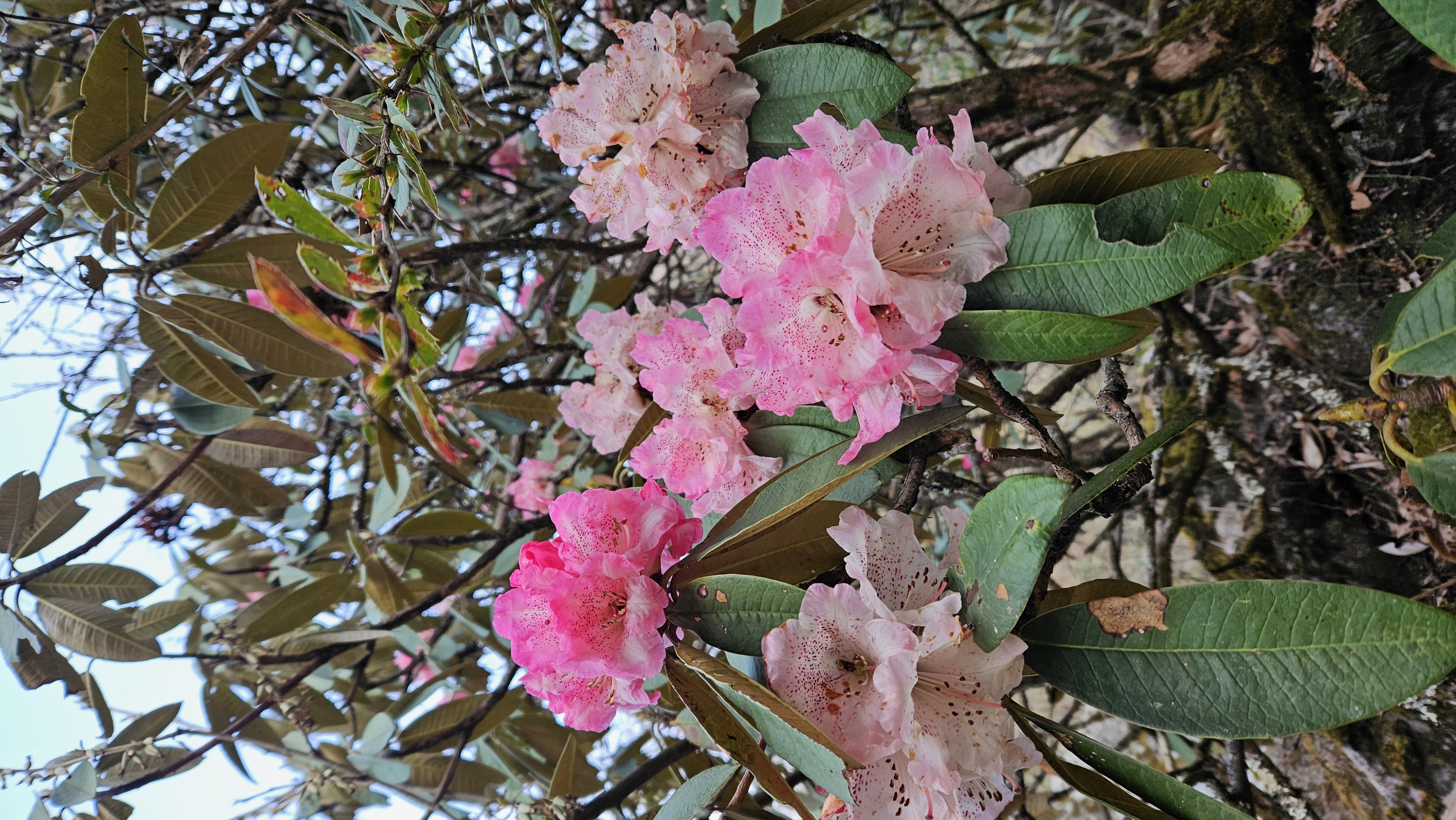
Imagine you have hiked for hours eagerly wanting to see the trees full of pink, red and white Rhododendron flowers. But once you reach the destination, you see nothing but the trees with bare branches. How does that feel? Sad, right? But this is the reality of many trees in Nepal these days.
Rhododendron season has arrived and many of us have already planned or visited the places popular for Rhododendron blooms. But the question is: can’t we simply enjoy watching the flowers sway in the wind without plucking them? Too often, people pluck the flowers and even break the branches to display them on their social media posts. These flowers, in their most vibrant phase, are plucked just to be thrown away.
Instead of discarding them, Rhododendron flowers could be used for medicinal purposes to treat pain, inflammation, and skin ailments, or processed into powders for pickles. During my visit to Taplejung recently, I saw the locals drying Rhododendron flowers to sell in the market for such uses.

Recently, a TikToK clip showing a person breaking the branches of a rhododendron tree to pluck the flowers went viral. It was met with angry comments; many demanded that the person should be punished for his act. Sadly, many people do not understand the value of Rhododendron flowers. More than just our national flower, Rhododendrons are home to thousands of birds and food source for bees and butterflies. They are a crucial part of the ecosystem.
Research has shown that once the flower is plucked, it is very hard to bloom from the same tree or it might take years to bloom again. It may be noted that Chandannath Municipality in Jumla has banned plucking of the Rhododendron flowers since 2019.

“We want to protect our Rhododendron forests because many people have been plucking their flowers and breaking their branches,” Birkha Bahadur Sarki, chairman of Dhalthapala Community Forest, told Khabarhub.com.
To protect the Rhododendron flowers, we must be aware of ourselves and educate others to not pluck Rhododendron flowers, and to admire them in the forest—where they belong. March to May is the best time for the Rhododendron trek in Nepal. Here are the five best to go see them.
Ghorepani-Poon Hill Trek
For those looking for the best place for Rhododendron trek, the Ghorepani-Poon Hill trek could be an ideal option. The trail passes through the dense Rhododendron forests. These forests would come alive during the spring season as it is the time when the rhododendron flowers with vibrant colors bloom. The forests will be blanketed by rhododendron flowers.
With the access of the road, the trek nowadays starts from Ulleri. After walking for around four to five hours, one can reach Ghorepani (2,860 meters). The next morning, you can hike to Poon Hill (3,210 meters) from where you get the spectacular view of Annapurna Himalayan Range, breathtaking view of sunrise, and Rhododendron forests.

Langtang Valley Trek
The Langtang Valley trek offers trekkers truly a magical experience of walking through lush Rhododendron forests. The month of March to May (spring season) is generally the best time to do this trek. This trek starts from Sybrubesi, four to five hours drive from Kathmandu, and it will take around five days to complete. Apart from beautiful Rhododendron forests, you get to trek through quaint villages, sparkling rivers, and witness gigantic snow capped mountains.

Tinjure-Milke-Jaljale trek
Located in Taplejung, Terathum, and Sankhuwasabha districts, the Tinjure-Milke-Jaljale trek is famous for its vibrant Rhododendron forests. Out of 31 species of Rhododendron flowers, 28 are found in the forests of TMJ. So this region is rightly called the capital of Rhododendron. Furthermore, the trek offers a chance to learn about the local culture and see spectacular mountain views of Makalu, Kanchanjunga and Everest. The trek starts from Hile, north of Dharan, and takes around eight to 10 days to complete.

Jugal Himal Base Camp Trek
Jugal Himal Trek is famous for the breathtaking mountain views and Rhododendron forests. This trail winds through lush Rhododendron forests, cascading waterfalls, serene mountains, and Sherpa villages. Mt Phurba Ghetchu, Gyalzen Peak, and Mt Jugal 1, 2 and 3 of Jugal Himalayan Range can clearly be seen on this trek. The trek starts from Tembathang and takes around 10 days to complete.

Peaky Peak Trek
Peaky Peak, which is situated in the lower Khumbu region of Solukhumbu district, is relatively a new trekking destination, offering panoramic views of Mt Everest, Mt Makalu, and Mt Kanchenjunga. This trail traverses through enchanting Rhododendron forests, which burst into a riot of colors during the spring season. Along with the Rhododendron forests, the trek promises an off-the-beaten-path experience for those who wish to avoid crowded and commercial trekking destinations. This trek starts from Dhap (2,850 meters), around six hours drive from Kathmandu, and ends in Phaplu.

Rhododendrons are a gift of nature. More than just a national symbol, they are vital to the ecosystem and bring joy to trekkers. Let’s appreciate them mindfully and preserve them for future generations.


Photos: Achitra Thieng

Jugal Base Camp: Haven for trekkers and mountaineers
It is difficult to express in words the pleasure of seeing more than five majestic mountains above 6, 000 meters by standing in between the clouds. It is almost unreal, something out of a fairy tale or a painting. But to see the evidence of this in beautiful tandem, you need to come out and walk up to Jugal Base Camp.
Despite being close to the Capital, Jugal Himal is yet to gain popularity in the trekking world.
Located in Sindhupalchowk district, 145 km from the Capital, everyone is curious as to why this region has not been able to attract trekkers and mountaineers.

Being a resident of the same district, the question was running in my mind for a long time. I am a hiking and trekking enthusiast. I have traveled to almost half of Nepal’s districts. In the meantime, I got an offer from Milan Tamang, a team member who first set foot on Gyalzen Peak (6151 meter), one of the peaks of Jugal Himalayan Range, in 2019, to facilitate a team to Jugal Base Camp. I jumped on the opportunity. I joined Footsteps 55 expedition team along with renowned adventurer and motivational speaker Pauline Sanderson, who holds a Guinness World Record for the world's longest climb.
The journey would not have been as memorable and enjoyable without the companionship and unwavering support of four daring women from the UK, to whom I was a translator and team moderator for the trek.

The first day of the trek started at 7 am. We took a jeep from Kathmandu to Tembathang, passing through Sukute beach and several villages like Balefi, Jalbire, Katike and Gumba. We were welcomed with genuine warmth and with playing traditional musical instruments in various places.
On the way, we came across many beautiful landscapes, awe-inspiring mountains and Bhotekoshi river. The river, which originates in the Tibetan region, is popular for rafting in Nepal.
When we reached Tembathang (2190 meters) in the evening, we saw local residents carrying khada (traditional ceremonial scarf) waiting for us to welcome. Actually, they were planning to welcome us in a grand manner by performing Sherpa Community’s popular dance Shilu and Shyabru. But the plan had to be canceled as a local had died a day before we reached there. This news had made all of us, including our foreign guests, saddened. We spent that night in a homestay at Tembathang.

Our team included four ladies, photographers, a cook, two helpers, and 13 porters.
We stayed the second night at Chendang and third night at Ne-Pemasaal, where we spent another two nights acclimatizing and exploring.
During the night at Ne-Pemasaal, I came out of the tent several times and looked at the stars that adorn the night sky like a diamond-studded veil. The moment was dreamlike. I saw this kind of scene only in movies.
It was the season to pick Yarsagumba, the world's most expensive medicinal fungus. While staying in Ne-Pemasaal, we decided to try our luck to hunt for the Himalayan Viagra, but lady luck was not with us on that day.

Ne Pemasaal (3500 meters from above sea level) is a beautiful hidden valley with spiritual significance, as it is believed to be the home of Guru Rimpoche for meditation. It is indeed a calm and serene valley. We then spent two more nights at Palmothang, which is the base for Jugal Range. This place offers stunning views of mountains and glaciers. The only problem of this place is that there is no proper supply of water. Our porters had to walk for around one-and-a-half hours to collect water for cooking. I hope that this problem will be resolved soon.
The hardest part of our journey was to walk from Palmothang to Jugal Base Camp. There was no proper trail. We had to navigate slippery icy trails, using ropes to descend and ascend steep sections. Thanks to our porters, and guides who helped us reach the base camp safely. They are the “unsung heroes” of expedition. Noone can imagine expedition without them.
Meanwhile, on our way back, we followed the trail to Panchpokhari (4514 meters), a popular destination for trekkers. The trail was exciting and most beautiful. Panchpokhari (five lakes) is a popular destination for Hindu and Buddhist pilgrims. It has been said that Panchpokhari area is the abode of Lord Shiva and Parvati and all the five ponds are their daughters.

Goals of expedition team:
1. To summit a new and unclimbed peak in Jugal
2. To explore skiing opportunities in the Jugal area
3. To discuss the impact of adventure tourism on local communities
4. To discuss the environmental impact of adventure tourism on the local environment

The team's objective was not only to reach the summit but also to explore the possibilities in the Jugal area.
Meanwhile, they successfully conducted a historic ski run on the Jugal glacier, first of its kind in the region.
A day before the ski run, a strong storm tore through the area. I experienced such a strong storm for the first time in my life. The tent, however, was tied firmly to the iron rods. At that time, I thought that it could be our last day of our life.
But the next day, the weather was clear and sunny and our foreign guests decided to try skiing on the lap of Jugal Himal.
Pioneering skiing on Jugal glacier
Observing the first-ever skiing expedition on the Jugal glacier was truly exhilarating. The untouched snow and glacier slopes can be a perfect place for skiing. This achievement not only showcased the versatility of the Jugal region but also highlighted the possibility that this region could be an ideal destination for winter sports.

Eco-friendly trekking initiatives
In addition to the thrill of skiing, the team was committed to promoting sustainable and eco-friendly trekking practices. Throughout our journey, we tried to spread awareness about environmental conservation and climate exchange. These efforts aimed to ensure that the beauty of Jugal Base Camp remains unspoiled for future generations.

Scenic splendor of Jugal Base Camp
Jugal Base Camp offers a 360-degree panorama view of towering peaks such as Mt Phurba Ghetchu Gyalzen peak, Yangri Peak along with Jugal 1, Jugal 2, Jugal 3, Jugal 4, Jugal 5, Ladies Peak and expansive glaciers, treating trekkers to a visual feast.
To ensure the success of the Jugal project, according to Pauline, we need to strategize.
A plan to promote Jugal as the most community and environmentally friendly destination in Nepal was to attract foreign tourists as they value the environment highly.
If they believe they are promoting a "green" trekking destination, it can be a major marketing tool- JUGAL CLEAN /JUGAL GREEN. Or a plan to promote Jugal as a community-focused destination, as helping communities is an attractive aspect of visiting Nepal- Ramro Jugal/ Hamro Jugal.

Future destination for adventurers
The Jugal Base Camp offers accessibility, stunning natural beauty, and opportunities for both trekking and expedition, making it a top destination for adventurers. I believe that the trekking enthusiasts and mountaineers will be attracted to this newly discovered trail.
My trek to Jugal Base Camp was more than just a physical journey. It was an enlightening experience and an opportunity to explore the beauty of a hidden gem.
I have trekked many times before, but going with an expedition team was a different experience. Every part of this trekking was inspiring, challenging and fun. I hope and love to see Jugal Base Camp evolving into a haven for trekkers and mountaineers.


Api Himal Base Camp: Exploring a hidden treasure of far-west Nepal
Which is that one place which comes to your mind when you think of trekking? Is it Annapurna Base Camp, Mardi, or Everest Base Camp? There are many places in Nepal that are yet to be explored. A beautiful trekking destination which has not gained much popularity, even among people who love to be in the lap of mountains, is Api Himal Base Camp Trek in the far-western region of Nepal.
This trekking route doesn’t have a long history. It was officially made accessible to the public only in 2020.
Though Api Himal Base Camp Trek is one of the shortest trekking destinations, it offers breathtaking sights, rocky mountain terrain, amazing food, pristine free-flowing river, steep gorges, and unique local culture.
We got an offer to explore this off-beat trekking destination, and without a second thought we packed our bags and bid adieu to Kathmandu.

We traveled on a bus for around 30 hours, enjoying the magical forests, beautiful landscapes, and sceneries of Doti, Dadeldhura, Baitadi, and Darchula, to reach the Api Himal Base Camp in Darchula, situated in the remotest part of Nepal.
We spent the first night on the bus and stayed at a hotel in Gokuleshwor of Darchula on the second. The next day, after indulging in a typical Nepali breakfast, we took a jeep at around 6: 30 am and headed towards Makarigaad.
We traveled in the four-wheeler for almost four hours along a perilous stretch of road.

After reaching Makarigaad, we had Nepali food—dal, bhat, tarkari with chicken—for lunch. I have never tasted such scrumptious food on the trekking route so far. We started heading towards Khandeshwori Village, our home for the night.
After climbing around 4,000 stairs, we reached the top of the hill from where we got a glimpse of a traditional village high up. We didn’t find a source of water on the way to the village. Finally, we reached Makarikot and found a tap. We were exhausted and at the same time excited to reach Naupata Homestay in Khandeshwori Village, where we were going to spend our third night.

We were so taken by the natural beauty of the surrounding that we didn’t even realize that we had walked for two hours to reach the village. We saw many eye-pleasing varieties of flowers everywhere in the village. There were traditional mud houses with clay stone roofing with maize laid out on it to dry.
A mothers’ group clad in traditional attire came to welcome us. They offered us flowers and tika and performed the traditional folk dance. Our team members couldn’t stop themselves and started dancing with them, donning traditional dresses.

The next day, as we were leaving, the owner of the homestay packed us some parathas and fried corn for lunch. She didn’t even charge us for it. Her kindness and love made us feel at home, creating a sense of belonging in that remote corner of Nepal.
We left the homestay at around eight in the morning and headed towards Siti. After walking through well-trodden trails for some time, we crossed a suspension bridge over the Chaulani river. The sounds of the water felt melodic and meditative.
The excitement turned into fear when we found out we had to climb uphill through a narrow trail. After walking for around half an hour through a steep trail, we reached Ghusa.

We were given cucumbers with the paste of salt and chilies by a woman and her grandson in Ghusa which helped us unwind and recharge ourselves to reach Nali, where we had pre-ordered lunch. After having lunch at Nali and resting for some time, we reached Siti in the evening.
Our next destination was Dhauliodar. We started hiking early in the morning, had breakfast at Khayakot, and moved towards Chirchire to have lunch. Enjoying picturesque views of alpine forest and vegetation, grasslands, flora and fauna, green pastures and mystic region with Chaulani river flowing on our side, we reached Dhauliodar in the evening.

Unfortunately, there was only a tea house which had only mattresses and sleeping bags. The night was chilly and we couldn’t sleep properly. The next day, after walking for around an hour and a half, we reached Api Himal Base Camp.
We were rewarded with views of snow-capped mountains and sounds of nature. The moment was surreal. Words can’t describe how we felt at that moment.

We took a lot of photos and videos. After that, we walked for two hours to reach the main attraction of the Api Nampa Base Camp, holy Kalidhunga Lake that lies at an altitude of 4,100 meters from sea level. The view was stunning and awe-inspiring. It had a calming effect on us. We felt like we had stepped into a fairytale world.
Though we wanted to stay there for hours enjoying the beauty of the lake, scenery, music of nature and the mountains, we had to return to the Base Camp as we had already planned to spend that night at Chirchire. The next day we reached Gokuleshwor at around 10 pm and headed back to Kathmandu.

Situated at an altitude of 7,132 meters from sea level, Mt Api is the highest mountain in Yoka Pahar Gurans Himalayan region. Api Nampa Conservation Area has been protecting this hidden treasure of the far-west Nepal bordering India to the west and Tibet to the north.
The trek offers spectacular views of Mt Api (7,132 meters), Mt Kapchuli (6,850 meters), Mt Rajama (6,537 meters), Mt Thado Dhunga Tuppa (5,368 meters) and the Api Himalayan ranges.
The trek can be completed in nine days. March to May and September to November are the best months for trekking to Api Himal Base Camp. The cost comes around to Rs 15, 000-20,000 per person.
Despite the challenges and its remoteness, we would highly recommend this adventure to those looking for an authentic Nepali experience.


